Many flights that end badly were in trouble before the engine started: a forecast nobody read past the destination METAR, a runway shorter than the hot afternoon needed, a fuel plan with nothing left over. Planning is where a pilot has the most time and options, and where an electronic flight bag can do the most good.
This guide walks through planning a flight in the order you would brief it: for each step, the safety reasoning and the regulation behind it, how the Flight Suite EFB helps, and what stays your job. The reasoning applies whatever EFB or paper chart you use. If you want the by-hand method first, with a worked nav log, read how to plan a VFR cross-country flight.
The rule behind every step: 91.3 and 91.103
Two sections of Part 91 frame everything below. 14 CFR 91.3 makes the pilot in command "directly responsible for, and ... the final authority as to, the operation of that aircraft." 14 CFR 91.103 then says what preflight action means: before beginning a flight, become familiar with "all available information concerning that flight."
For an IFR flight or one not in the vicinity of an airport, 91.103 names the minimum: weather reports and forecasts, fuel requirements, alternatives if the flight cannot be completed as planned, and any known traffic delays ATC has advised you of. For every flight, it adds runway lengths at the airports you intend to use and takeoff and landing distance information.
An EFB can gather that information, cross-check it and point at what does not add up. It cannot take the responsibility. Everything the Flight Suite EFB shows is advisory, and its screens say so: the app is a second set of eyes, not the pilot in command.
1. Start with yourself and the airplane
Why it matters. The best route in the world does not help a pilot who is not current, not fit to fly, or in an airplane that is not airworthy. Under 14 CFR 91.7, the pilot in command decides whether the aircraft is in condition for safe flight. Currency is in Part 61: a flight review within the preceding 24 calendar months under 61.56, and three takeoffs and three landings in the same category and class in the preceding 90 days to carry passengers under 61.57, full stop at night for night passengers. Personal minimums sit on top: the weather you will not fly in, decided on the ground when nobody is waiting at the airplane.
How the EFB helps. At a flight school on Flight Suite HQ, the plan shows the pilot's checkout in the chosen aircraft, medical and flight review, and the aircraft's open squawks, deferred items and inspections as they will stand at the end of the booking. A record the app cannot read is never presented as clean. Personal weather minimums live in your profile, and the risk assessment checks each airport's weather against the strictest of yours, your instructor's and your school's. An independent pilot's currency is in the logbook.
What stays yours. How you feel today. No app can run IMSAFE for you.
2. Choose a route that leaves you options
Why it matters. A route decides what you can glide to if the engine quits, what airspace you must talk your way through, and how much of the flight is over water, forest or mountains. Keeping a landable field within reach costs a few minutes and buys a lot of options.
How the EFB helps. Type the route in the route bar, or tap airports, navaids and fixes on the chart. Or let FlightMatrix HQ, the EFB's route planner, draw a VFR route between your first and last airports. It keeps clear of TFRs active at your time, prohibited and restricted areas, terrain within 1,000 ft of the cruise altitude, and any Class B, C or D airspace or Mode C veil you have not chosen to enter, flying over or under them only where the rules allow. It also avoids open water beyond gliding distance of land and warning areas, unless you allow them. Every leg says why it goes where it goes, and the route goes into the route bar, where the ordinary airspace, terrain and fuel checks run on it. The vertical profile (on the website) draws terrain, charted obstacles and every airspace crossing under your cruise altitude.
What stays yours. Check a planned route against the current chart as you would one you drew yourself.
3. Pick an altitude for the wind, the terrain and the rules
Why it matters. Altitude is where terrain clearance, glide range, wind, fuel and airspace meet. Higher usually means more glide options; a headwind up there can make it slower and thirstier. Above 3,000 ft above the surface in level VFR cruise, 14 CFR 91.159 also sets the hemispheric rule: odd thousands plus 500 ft on magnetic courses of 0 through 179 degrees, even thousands plus 500 ft on 180 through 359.
How the EFB helps. The altitude picker lists the VFR altitudes for your course (IFR altitudes on an IFR plan), each with its time, trip fuel, wind component and anything it runs into, and marks the fastest and the one that burns least fuel. A route with several legs can have an altitude per leg, and the route bar turns amber when a leg flies the other direction's altitude. In FlightMatrix HQ, "Choose for me" picks the highest altitude, up to the ceiling you set, that keeps clear of what you have not ticked and that the airplane actually climbs to with a third of the trip left.
What stays yours. Oxygen (91.211), cloud clearances (91.155), and whether the altitude suits this airplane and pilot today.
4. Airspace, TFRs and special use airspace
Why it matters. Airspace violations are rarely deliberate. They come from a shelf misread on the sectional, a TFR issued the morning of the flight, or a restricted area assumed to be cold. TFRs are issued by NOTAM and pilots are responsible for checking them during planning (AIM 3-5-3). For military operations areas, the AIM warns that activity status "may change frequently" and tells VFR pilots to use extreme caution in an active MOA (AIM 3-4-5).
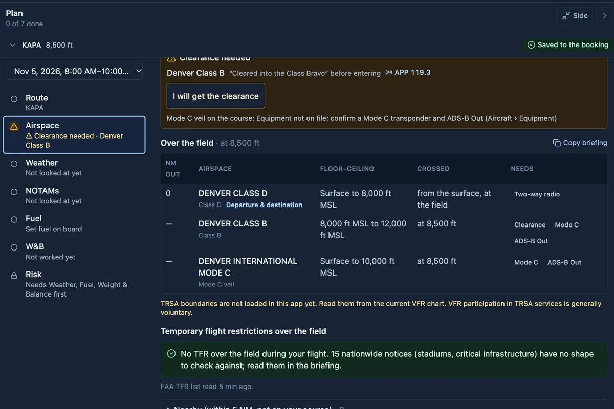
How the EFB helps. The Airspace step lists everything your course meets at your altitude, in the order you meet it: Class B, C, D and E surface areas, special use airspace, TFRs and TRSAs, each with its floor, ceiling and what it requires. When the course needs a Class B clearance or radio contact, it asks you to confirm you will get it. If the check could not run, it says not to treat the route as clear. On the chart, MOAs and restricted areas show their status from the ATC schedule: red when active now, amber when due within three hours, grey when not active, refreshed every two minutes (on the website now, in the app from its next update). Without a live status, they are drawn with their published times.
What stays yours. A TFR can appear after you plan. Check again close to departure, and ask ATC or Flight Service about special use airspace you will cross.
5. Weather and winds aloft
Why it matters. A good weather briefing reads the trend, not just the current METAR: the TAF at your arrival time, the advisories along the route, icing and turbulence at your altitude, and the winds that set your groundspeed and fuel. The AIM notes that a pilot can receive a regulatory compliant briefing without contacting Flight Service and points to AC 91-92, Pilot's Guide to a Preflight Briefing (AIM 7-1-5).
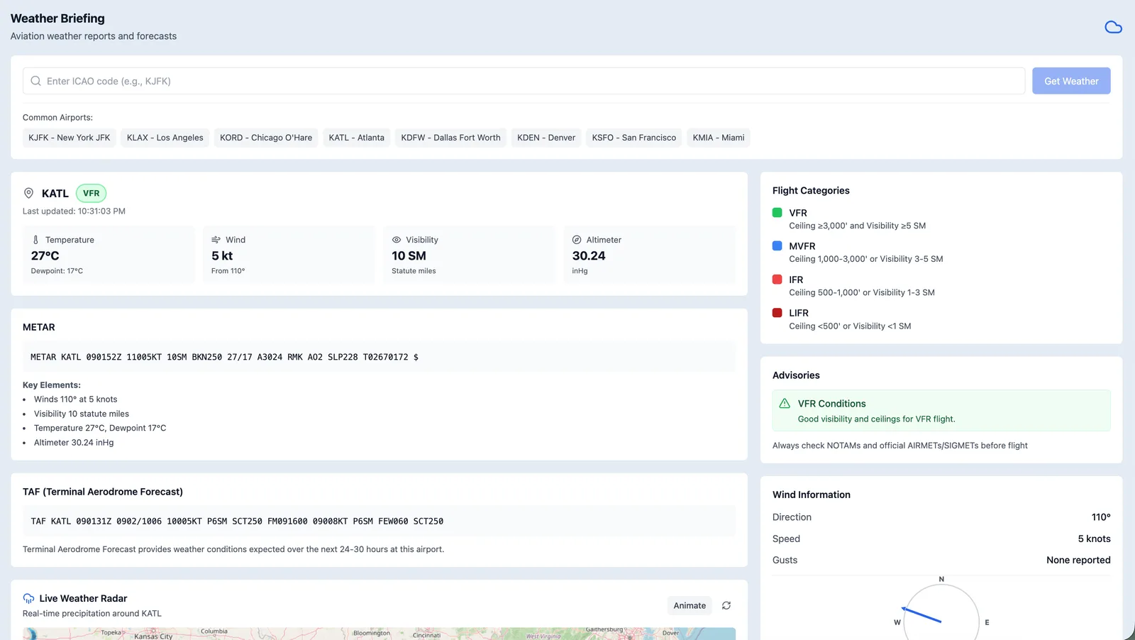
How the EFB helps. The Weather step starts with your route: the flight category at every airport, and the TAF at each end for the time it matters, the departure's at departure and the destination's at your ETA. Then the SIGMETs, AIRMETs and PIREPs on your course, and the G-AIRMET icing and turbulence and the freezing level at each leg's planned altitude and time (website now; app next). The GFA charts (AIM 7-1-4) are on the step too, and the chart's layers add radar, satellite and the convective outlook.
Winds changed this month. The text winds and temperatures aloft tables many pilots grew up on (the FB, still often called the FD) were discontinued with the retirement of the NAM model on 3 November 2026. The EFB now reads the wind forecast behind the Aviation Weather Center's Graphical Forecasts for Aviation, and the nav log and the winds along the route say so. Two practical differences: the forecast points are a grid one degree apart rather than reporting stations, and the GFA gives no temperatures aloft, so the EFB does not show any.
What stays yours. Interpreting it. Decide in advance what you will do if the destination comes in lower than forecast, and call Flight Service whenever you want a briefer's eyes on it.
6. NOTAMs and traffic delays
Why it matters. NOTAMs carry closed runways, unlit towers, inoperative navaids and approaches out of service. Most are irrelevant to a given flight, which is why the one that matters gets missed. 91.103 also names "any known traffic delays" for IFR flights, and a ground stop at your destination is something you want to know about before you leave.
How the EFB helps. The NOTAMs step groups each airport's NOTAMs by what they are about, most important first, and you mark each airport reviewed. The route briefing lists every NOTAM within 25 nm of the route in the order you reach it. A Traffic flow card on the weather briefing shows ground stops, ground delay programs and other traffic management initiatives at your departure and destination, refreshed every two minutes, and when the feed is unavailable it says so instead of implying nothing is happening. A booking, planned flight or filed IFR plan can also show its ATC status, including an EDCT when ATC assigns one; aircraft on the FAA's LADD privacy list are not shown (both on the website now, in the app from its next update).
What stays yours. Reading the NOTAMs that apply, and checking again close to departure.
7. Runway performance and density altitude
Why it matters. A runway that is comfortable in January can be marginal in July. Density altitude, which is pressure altitude corrected for temperature, sets how the engine, propeller and wing perform, and a high, hot field with a full airplane can need far more runway than the sea-level figure suggests (Pilot's Handbook of Aeronautical Knowledge, chapter 11, Aircraft Performance). This is why 91.103(b) requires runway lengths and takeoff and landing distance information for every flight.
How the EFB helps. On the website, a chip at each end of the route reads, for example, "Runway: 1,240 ft margin" and opens the takeoff and landing check. It shows the field's pressure and density altitude from current weather, reads the POH figures at them (yours, the school's POH table, or a shared reference checked by the Flight Suite HQ team), corrects them for wind and surface, and checks each runway with a margin. Without a POH figure it asks for one; it never makes one up. A takeoff and landing quick reference gives the distances at sea level and 15 °C, and where no POH is loaded, typical figures for the type show in amber, labelled as an estimate and never used for the runway check.
What stays yours. The POH governs. Grass, a slope, an obstacle off the end, or a heavier airplane than the chart assumes all need your own numbers and your own margin.
8. Fuel and reserves
Why it matters. Fuel exhaustion and fuel mismanagement remain among the most avoidable ways to end up in a field. 14 CFR 91.151 requires enough fuel, considering wind and forecast weather, to reach the first point of intended landing and then fly for 30 minutes by day or 45 minutes at night at normal cruising speed. Under IFR, 91.167 adds the alternate, when one is required, and 45 minutes after that. Those are minimums, not targets.
How the EFB helps. The nav log works out each leg's groundspeed, time and fuel from your aircraft's performance profile and the forecast winds, with top of climb and descent. It judges the fuel you land with against the 91.151 reserve, 30 or 45 minutes from your departure time and place, and an IFR plan uses 45. Fuel stops can be added on the route, each landing checked against the reserve on its own, with the FBO's posted price where there is one.
What stays yours. A reserve that suits you, a dipstick at the airplane, and landing for fuel early rather than late.
9. Weight and balance
Why it matters. An airplane outside its weight or CG limits is operating outside its approved flight manual, which 14 CFR 91.9 forbids, and an aft CG can make a stall harder to recover from. Chapter 10 of the Pilot's Handbook of Aeronautical Knowledge covers the method.
How the EFB helps. The fuel figure from the fuel step carries across, you enter the people and baggage at each station, and the sheet gives the total weight, the CG and whether the loading is inside the aircraft's envelope.
What stays yours. Real weights, and the aircraft's current empty weight and arms from its weight and balance record.
10. A risk assessment you actually look at
Why it matters. Each risk on its own can look acceptable: a little night, a little wind, a pilot a little out of practice, an unfamiliar airplane. A flight risk assessment adds them up so the go or no-go is a number you have looked at rather than a feeling.
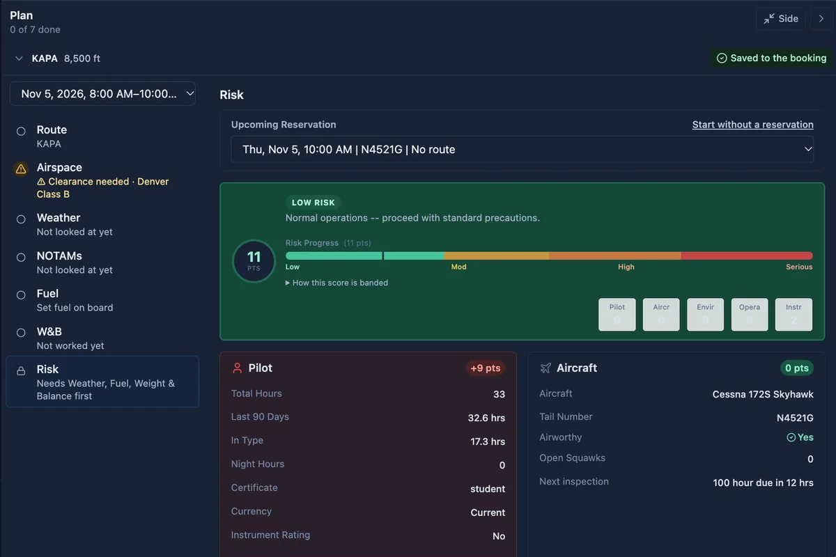
How the EFB helps. The Risk step unlocks once weather, fuel and weight and balance are done, so it scores a finished plan. It is filled in from the flight, the pilot and the aircraft, with the IMSAFE questions, and it checks each airport's weather against your minimums and lists a short runway margin to confirm. Some answers are an automatic No-Go and cite the regulation, such as alcohol under 91.17. At a school, missing endorsements or a lapsed medical are listed to confirm before flight, and a school can choose to make them No-Gos. More on how schools use it is on the safety and risk assessment features page.
What stays yours. Answering honestly, and treating a high score as a reason to change the plan, not the answers.
11. IFR: alternates, departures, MEAs and lost comms
Why it matters. An IFR plan has several rule-driven checks that are easy to get wrong under time pressure:
- The alternate. Under 14 CFR 91.169, an IFR flight plan names an alternate unless the destination has an instrument approach and the forecast, from 1 hour before to 1 hour after your ETA, is at least a 2,000 ft ceiling and 3 statute miles. The alternate itself must forecast at or above its published alternate minimums, or 600 and 2 for a precision approach and 800 and 2 for a non-precision one where none are published.
- The departure. Takeoff minimums in 91.175(f) bind operators under Parts 121, 125, 129 and 135, not a private Part 91 flight. Obstacle departure procedures are still there for a reason: the AIM says ODPs "are recommended for obstruction clearance" (AIM 5-2-9).
- Minimum altitudes. 91.177 keeps you at or above the MEA, or the MOCA where both apply and the navigation signals are available.
- Lost communications. 91.185 sets the route (assigned, vectored, expected, then filed), the altitude (the highest of assigned, the minimum IFR altitude and expected) and when to leave the clearance limit.
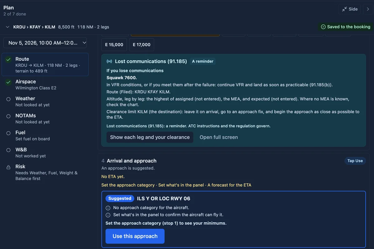
How the EFB helps. Switch a plan to IFR and the route step becomes six stops, from aircraft and time to filing, each ready or saying what is missing. It shows the FAA's preferred routes and routes recently filed; the departure's takeoff minimums and departure procedures; each airway segment's MEA and MOCA, flagging a planned altitude below the MEA; whether an alternate is required under 91.169, from the destination TAF an hour either side of arrival, and the alternate against its minimums; the approaches your panel and category can fly; and a 91.185 lost-communications card. Procedures are drawn on the chart as flown, and in flight the strip can follow the loaded one leg by leg (on for independent pilots; a school turns it on). All of this is on the website now and in the app from its next update.
What stays yours. The chart and the clearance. MCAs and GPS MEAs are not in the data the app reads, so the screen tells you to check the chart, and ATC instructions always govern.
12. File the flight plan
Why it matters. 14 CFR 91.173 requires an IFR flight plan and a clearance to operate under IFR in controlled airspace. Within the continental US a VFR flight plan is not normally required, but an activated one is what starts search and rescue if you have not closed it within half an hour of your ETA (AIM 5-1).
How the EFB helps. The ICAO flight plan form is filled in from your route, aircraft and profile, with help to pick the altitude and work out the elapsed time, and a separate plan for each leg when the route has fuel stops. Filing straight from Flight Suite HQ is coming; until it opens, copy the plan and file it in 1800wxbrief.
What stays yours. Checking every field, and opening and closing a VFR plan.
13. Taxi and departure
Why it matters. At an unfamiliar airport, a wrong turn onto an active runway is a runway incursion. The FAA's runway safety program exists because of it.
How the EFB helps. Before you go, the 3D airport view (on the website) shows the field in photorealistic 3D from short final to the runway most into the wind, so the layout is familiar before you arrive. On the ground, type your taxi clearance as you copy it, such as "A C cross 13 D E", and the chart draws the route along the taxiways, with the next turn and each hold-short shown large and said aloud. It never tells you to cross a runway your clearance does not name: one it does not name is a hold short. It opens by itself after landing, where OpenStreetMap names the taxiways (website now; app next).
What stays yours. ATC and the airport diagram are the authority. Read back every hold-short and look outside.
14. In the air: the strip, glide range and GEAR DOWN
Why it matters. In-flight tools have to be one tap away and readable at a glance in bumpy air. Our article on using an EFB in flight training covers keeping your eyes outside.
How the EFB helps.
- The flight strip shows groundspeed, track, time to the next waypoint and the nearest airport, on controls sized for turbulence.
- Glide range. A glide ring shows how far you could glide in still air from your GPS altitude, keeping 500 ft above the terrain, with the nearest airport inside it circled. Engine out turns the magenta line to the best field within gliding range, allowing for the wind, with squawk 7700, best glide and your checklist, and Undo (website now; app next).
- Synthetic vision shows the ground, towers, runways and traffic ahead, red where they reach your altitude and amber within 1,000 ft. Not for navigation.
- GEAR DOWN. In an aircraft marked retractable, within 2 nm of your departure or destination and below 500 ft above it while not climbing, the strip shows GEAR DOWN in red and says "Gear down!", repeating every 5 seconds up to four times until you tap Gear down, land or climb away. It stays quiet on the takeoff roll and arms again for the next circuit. It is a reminder, not a gear warning system: the app cannot see your gear (website now; app next). Why it matters is in our article on gear-up landings and retractable insurance.
- Offline. Save the route's charts before you go, and the chart, the plates and your plan keep working with no signal.
What stays yours. Flying the airplane and looking outside. Terrain comes from an elevation model and obstacles from the FAA's obstacle file; none of it is a terrain clearance check or a substitute for the current chart.
15. After you land: the debrief
Why it matters. The flight you just flew is the cheapest lesson you will get, and it is clearest on the day.
How the EFB helps. Record the flight, or let it record itself from the taxi, and Flight Recap splits it into phases, from the taxi to the landing roll, measuring each approach and landing against the ACS as advice, never a grade (website now; app next). An independent pilot can send the recorded flight to any CFI, who replays it, grades it and writes back from a link with no account of their own.
What an EFB can and cannot do
An EFB is good at the arithmetic and the cross-checking (winds against altitude, fuel against reserve, route against airspace, runway against POH) and at not forgetting: the NOTAM on page four, the alternate rule, the gear on a busy final. It cannot judge how you feel, what the clouds over the ridge are doing, or whether today is a day to stay home. That part is the pilot's, and 91.3 says so.
The Flight Suite EFB is included in the subscription of a school that uses Flight Suite HQ, and a pilot without a school can use it for $8 per month after a 14-day free trial. See everything the Flight Suite EFB does.
Frequently asked questions
What preflight information does 14 CFR 91.103 require?
For every flight, runway lengths at the airports you intend to use and takeoff and landing distance data. For IFR flights or flights away from an airport's vicinity, also weather, fuel requirements, alternatives and known ATC traffic delays.
How much fuel reserve do I need for a VFR flight?
In an airplane, 14 CFR 91.151 requires enough fuel to reach the first point of intended landing and then fly 30 minutes by day or 45 minutes at night at normal cruising speed. Many pilots and schools plan more.
When do I need an alternate on an IFR flight plan?
Under 14 CFR 91.169, unless the destination has an instrument approach and the forecast from 1 hour before to 1 hour after your ETA is at least a 2,000 ft ceiling and 3 statute miles visibility.
Can an EFB replace a weather briefing?
The AIM says a pilot can get a regulatory compliant briefing without calling Flight Service, using automated resources. An EFB gathers that information, but you still have to read and interpret it, and a briefer is always available.
Does the GEAR DOWN reminder replace a gear warning system?
No. The app cannot see the gear. It reminds you on every approach in an aircraft marked retractable, within 2 nm of the field and below 500 ft above it, but the checklist and the airplane's own warning still come first.